UK weather: Britain threatened with MORE thunderstorm chaos as Met Office warnings in force

A battle between a Scandinavian cyclone and tropical anticyclone threatens thunderstorm chaos into mid-week.
Downpours will split the nation, with Scotland and northern regions in the deluge firing line pelted as the south turns drier.
A huge area of low pressure to the north of the UK will lock horns with tropical humidity circling a high-pressure ‘anticyclone’ to the west.
Met Office thunderstorm warnings are in force today across much of the UK, putting Britons on alert for flooding, power cuts and travel chaos.
Met Office meteorologist Alex Deakin said: “Low pressure is sitting up towards Scandinavia, and high pressure is trying to build from the southwest.
“The closer you are to the high, the better chance you have of staying dry, but if you are after rain, then you need to be closer to the low pressure.
“This means things will be showery, particularly close to the low, with most of the showers across the north and the east, it will be largely dry in the south, particularly down to the southwest close to that high pressure.”
It comes after a weekend deluge, fuelled by soaring humidity, pelted swaths of the country with heavy downpours.
LATEST DEVELOPMENTS:
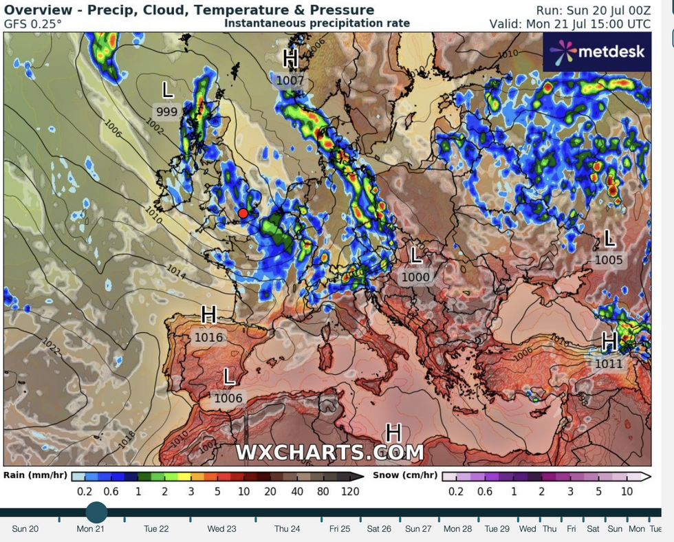
WX CHARTS
|
Cool conditions will dominate British weather this week
An amber thunderstorm warning, however, did not yield the fireworks some were expecting, with rain turning out to be the bigger menace.
Meteorologists say atmospheric energy profiles in the end were not strong enough to trigger the anticipated eruption.
As things turn unsettled, winds from the north will herald a cooler spell, although unusually hot ocean temperatures will keep the mercury in the mid-20Cs.
Deakin said: “A north-westerly airflow is coming in, and by the time we get to Wednesday, Thursday and into Friday, the most likely pattern is low pressure to the northeast and high pressure to the southwest.
WX CHARTS
|
Rain is forecast to strike Britain again this week
“With a north-westerly airflow, generally that would bring cooler than average conditions, but mostly around the UK the sea is warmer than average and with the strength of the sun, it will feel warmer where the sun is out.”
Thunderstorms will threaten Britain through the next couple of days before ‘pleasant weather’ returns.
While sun-seekers hoping for another heatwave may be disappointed, temperatures will hover just above average for the time of year.
Jim Dale, meteorologist for British Weather Services and co-author of ‘Surviving Extreme Weather’, said: “There is going to be the risk of thunderstorms through the next couple of days, potentially until Wednesday.
“Then we are going to see a period of calmer, more pleasant weather towards the end of the week, with temperatures lifting in parts of the country.
“Sea temperatures are high, so even if we get a northerly, temperatures will still stay around average for the time of year or just above.”
The Met Office has thunderstorm alerts in force across the country today, with further heavy rain threatening floods.
Up to two inches could fall in parts, sparking warnings for travel disruption, power cuts and mobile phone outages.
A Met Office spokesman said: “Heavy downpours of rain will be the primary hazard, but lightning strikes are also likely along with the potential for hail and gusty winds.”
Jason Nicholls, lead international forecaster for AccuWeather, said: “It will be unsettled early in the week, with scattered showers until Wednesday before it turns drier and brighter.
“Temperatures will be close to average.”